St Marys Books
Telephone: 01780 763033 Email: info@stmarysbooks.com
...or pay a visit to our shop in Stamford, Lincolnshire, UK
Skip navigationMaps & Prints > Cartographers M-Z > John Ogilby > The Road From Nottingham To Grimsby in the Count of Lincolne Original Map
The Road From Nottingham To Grimsby in the Count of Lincolne Original Map
John Ogilby
Ref. 097171
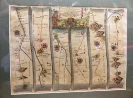
Circa 1675 (London)Plate 78 Circa 1675 taken from Ogilby's "Britannia" the first national Road Atlas of any Country in Western Europe. Coloured with a little age-toning / browning in places otherwise in good condition, the map itself measures approximately 44cm x 33cm and is mounted with a dark green mount taking the measurement to approximately 54cm x 42cm. It shows the journey from Nottingham to Grimsby in six strips, mile by mile, showing every town, village and milestone along the way. Large decorated title cartouche to the top.
Book Condition: Very Good
Jacket Condition: No Jacket
Size: see description
Binding: Soft