St Marys Books
Telephone: 01780 763033 Email: info@stmarysbooks.com
...or pay a visit to our shop in Stamford, Lincolnshire, UK
Skip navigation- Books
- Jane Austen
- Gift Ideas
- Gifts Under £ 50
- Decorative Boards
- Harry Potter
- Children's
- Wisden
- Bindings
- The Beeton Collection
- Cookery
- First Editions
- Illustrated
- Medical
- Folio Society
- Military
- Motoring
- Natural History
- Rural Sports
- Magic
- Rare Books
- Featured Books
- Arthur Rackham
- More Categories...
- Topography
- Maps & Prints
- Taxidermy
Maps & Prints > English Counties A-L > Leicestershire > Map of Leicestershire
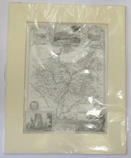
Map of Leicestershire
Ref. 108032
Steel engraved map of Leicestershire with images of Belvoir Castle, Ulverscroft Abbey and Donington Castle. Measuring 19.5cm x 26cm or 27.5cm x 35cm inclusive of a cream coloured mount. In excellent condition.
Book Type: Map


- Jane Austen
- Gift Ideas
- Gifts Under £ 50
- Decorative Boards
- Harry Potter
- Children's
- Wisden
- Bindings
- The Beeton Collection
- Cookery
- First Editions
- Illustrated
- Medical
- Folio Society
- Military
- Motoring
- Natural History
- Rural Sports
- Magic
- Rare Books
- Featured Books
- Arthur Rackham
- More Categories...
- Topography
St Mary's Books And Prints, 9 St Marys Hill, Stamford, Lincolnshire, PE9 2DP, England. We are open 7 days a week: Mon-Sat: 9am-6pm, Sun: 9am-5pm.
Registered in the United Kingdom, Company Registration number . VAT Registered, number .
Our website uses cookies so that you can place orders and we can provide a better service. Continue to use the site if you're happy with this, or find out how to manage cookies. x