St Marys Books
Telephone: 01780 763033 Email: info@stmarysbooks.com
...or pay a visit to our shop in Stamford, Lincolnshire, UK
Skip navigationMaps & Prints > Pieter Van Den Keere Map Of Lincolneshire
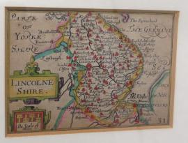
Pieter Van Den Keere Map Of Lincolneshire
Ref. 000000
An antique map by Pieter Van Den Keere. The maps of England and Wales by Van Den Keere were based on those by Christopher Saxton. In 1927 George Humble published a Major Edition of "Speed's Atlas" who in turn produced the Van Den Keere maps as "pocket editions" For these he used the descriptive texts of the large Speed maps and thereafter they were known as Miniature Speeds. This one measures approximately 12cm ( 5inches ) in width and 8.5cm ( 3.5 inches ) in height. This one is mounted and framed in a simple black and gold style frame and ready to hang. Hand coloured.