St Marys Books
Telephone: 01780 763033 Email: info@stmarysbooks.com
...or pay a visit to our shop in Stamford, Lincolnshire, UK
Skip navigationMaps & Prints > Map of the County of Bedford, from an Actual Survey Made in the Year 1825
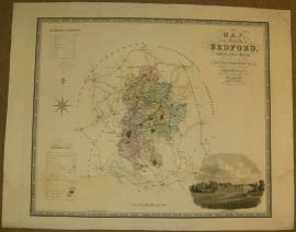
Map of the County of Bedford, from an Actual Survey Made in the Year 1825
C. & J. Greenwood
Ref. 031808
Published By: Published By the Proprietors Greenwood & Co. (London)
Published January 26th 1831. Engraved by J. & C. Walker. Hand coloured to map and key. Uncoloured steel engraving of Woburn Abbey (Seat of the Duke of Bedford) to bottom right hand corner. Generally clean and bright. Some minor wear to edges with a few small closed tears. Slight water damage/stain across lower quarter of map. Unframed, unmounted. Map measures approx 68cm x 57cm. Measurements including margin are approx. 82cm x 65cm. Images available on request.
Book Condition: Good
Binding: Hardback